 Tweet
Tweet
Originally posted by Evan
View Post
-
Maybe fuel burn had been lighter than expected for whatever reason and the plane wasn't light enough yet to climb economically to FL370. -
- Maybe because they were not cleared to do so.
- Ok, but if they wanted higher and were not "proactively" cleared, why didn't they request it to ATC?
- How do you know they didn't try to? Maybe they tried but couldn't make contact (after all, why wouldn't they answer the Atlantico center).
- Or maybe they were already with big troubles and too much workload by when they got to SALPU (when dealing with an unreliable airspeed situation and a lot of systems going off-line as a result is not the best time to request a more economic flight level). Or maybe they never reached SALPU (I don't know where is SALPU relative to the point of last radio contact and to the zone of loss of control and crash)
--- Judge what is said by the merits of what is said, not by the credentials of who said it. ---
--- Defend what you say with arguments, not by imposing your credentials ---Comment
-
Hmmm....
the flight plan reads:
What does that actually mean? is FL270 planned to be achieved by the time they reach SALPU? Or would they request permission to climb once they are at SALPU?UN873 INTOL/M082F350 UN873 SALPU/M082F370
Communications go like this:
So apparently while going by INTOL, they estimated to arrive at SALPU about 13 minutes later. Here at INTOL, they were ordered to maintain FL350. Should they have requested 370 in this conversation?01:35:15 � AFR 447 -AIR FRANCE FOUR FOUR SEVEN, by checking
INTOL zero one three three, level three five zero,
SALPU zero one four eight, next ORARO zero
two zero zero, selcall check Charlie Papa Hotel
Quebec.
01:35:38 � ACC-AO Acionamento do c�digo SELCALL
01:35:43 � AFR 447 -AIR FRANCE FOUR FOUR SEVEN, thank you.
01:35:46 � ACC-AO -Welcome, maintaing flight level three five zero,
say your estimate TASIL?
01:35:53 � ACC-AO -Say your estimate TASIL?
While not answering the request to estimate TASIL, ORARO had already been given and it's not far from there.
Way, way back in the old thread I posted a graph of a sloppy reconstruction of the average ground speed, which started to drop dramatically after 01:53 at EPODE (Is that now SALPU??). resulting in an average speed of only 300KTS between EPODE and ORARO. This is strange, since at 01:33z AF447 already estimated the arrival time at ORARO correctly to be 02:00z. Did they plan to slow down? Or did they reduce speed due to entering turbulence? Somewhere I read that the manual of the A330-200 gives the turbulence penetration speed as 260KTS. Or is the reduced ground speed maybe a sign of the aircraft climbing?
I'm confused...Comment
-
Normally, pilots request clearance before a waypoint so as to cross it at the altitude given in a flightplan (otherwise a flightplan and the format used for communicating speed and altitude wouldn't make much sense).Originally posted by mfeldt View Post
Like MCM already stated, a flight plan is just a plan. What really happens on the flight as to routeing, speed and altitude is a different matter and of course any or all of these parameters can be changed by the flight crew or ATC. So the question is not what the crew of AF447 "SHOULD" have done about the altitude. They simply didn't do it and the only question possibly relevant to the accident is "why" they didn't do it.Originally posted by mfeldt View Post
Ground speed is a messy thing to deal with when talking about flight because it has so little relevance to the operation of an aircraft. If the manual says that the turbulence penetration speed for the A330-200 is 260kts, then of course it is stating AIRspeed not ground speed. A reduction in ground speed can have several reasons but at this point it is difficult to say what caused a drop in ground speed.Originally posted by mfeldt View Post
As your post referred to a "sloppy (!)" reconstruction of average ground speed, I suggest we drop the topic of ground speed until there is any hard evidence about it and until we have the airspeed data to correlate with the ground speed data. Anything else would be wildly speculative.
No need to be, mfeldtOriginally posted by mfeldt View Post
Comment
-
Maybe you should go back and review your calculations. AF447 was on the UN873 airway, where EPODE is halfway between INTOL and TASIL. SALPU is less than a third of the distance to TASIL, so they are not the same waypoint. SALPU is approx 215nm from the first ACARS transmission.Originally posted by mfeldt View Post
One thing that I considered from the very beginning was the possibility of a collision with something that wasn't supposed to be there, something covert or illegal flying on a stealthy course parallel to the UL695/375 airway. I thought this because it seemed strange that AF447 disappeared in such close proximity to this major intersection of crossing airways.
UN873 intersects the UL695/375 airway perpendicularly at ORARO, and the first ACARS occurs just beyond that intersection. When I overlay the weather images, it appears that such a collision would have occurred in very poor visibility within the cloud formation. As we have learned from the Gol 737NG collision in Brazil, if the other a/c does not have its TCAS active, TCAS can fail to warn against encroaching traffic. If the illegal aircraft had been monitoring flight plans for that day, they would have expected AF447 at FL370, so maybe they were at FL350. AF447, I'm told, would have deviated from the flight plan and maintained FL350. I speculate that a non-catastrophic collision might have severely damaged the front of the A330, including the pitots, resulting in the ACARS messages that were received. The second plane might have flown a bit further and then disappeared in the ocean (although I would expect something to be recovered). I'm sure there is a reason why this theory can be refuted (other than the remote odds of course), and I'm counting on the forum to let me know what that is.Comment
-
That's an interesting thought, and since we have now started speculating I would like to throw in another idea: What if it was a bomb? Not the political, terrorist kind of bomb that someone would claim responsibility for but more like the life-insurance fraud or personal act of revenge kind of bomb. It could have been small enough to cripple the aircraft but not blast it right out of the sky which could explain the progressively worsening automated reports from the aircraft. Any thoughts or comments about that?Originally posted by Evan View PostComment
-
I don't know if it can be ruled out, but the aircraft did nor decompress, nor was there any ACARS indication of overpressure at the beginning of the sequence. There was also no MAYDAY, as one would expect after a non-catastrophic explosion. If a timed explosive were planted on the aircraft outside the pressure hull, I suppose that could be a possibility. But none of the recovered wreckage indicated fire or explosion. Most importantly though, how do you directly explain the ACARS sequence, which begins with an air data disagree? The sequence you would expect from an explosion would have a different 'fingerprint'.Originally posted by Peter Kesternich View Post
The problem with a bomb theory is that it is pure speculation. Nothing points to it. I'm trying to speculate from clues in the evidence we have.Comment
-
Okay, so where are the clues in the evidence for your theory?Originally posted by Evan View Post
Comment
-
http://www.aviationweather.ws/092_Circulation.phpFlying through the ITCZ usually presents no great problem if one follows the usual practice of avoiding thunderstorms. He usually can find a safe corridor between storms
In short, you fly like a halfback runs, to "daylight". You can't set a flight path and grimly stick to it.Comment
-
Close proximity to the UL695/375 airway, deviation from planned flight level, near zero visibility. Light collision might have sheared off the pitots. That's all I've got for this one.Originally posted by Peter Kesternich View PostComment
-
One other stick in the spokes - if you were an illegal or unplanned flight, wouldn't you avoid regular airline routes? If you are looking to be not seen or not found such as a drug flight South America to North Africa wouldn't you steer clear of other air routes? Then again, not being in a regularly used air route would also look suspicious wouldn't it? Hmmm - you may have something - I'd give this higher probability than a bomb.Originally posted by Evan View PostComment
-
A "light" collision at M.80?
Whatever.
Flights often do not climb when the flight plan says they will. As I said it is a "heads up".
When you get your route clearance from ATC, it is for the horizontal track. So, they have been cleared to follow that ground track between waypoints. The altitudes are advisory only... and mean absolutely nothing in terms of clearances.
The crew get cleared to a level, and maintain that level until they wish to change it, or they are required to change it by ATC because of other traffic. The point that they wish to change it depends on actual winds, actual weight, the winds at the time, etc.
I'll make it clear again - the absence of a request for a climb means absolutely NOTHING at all, and it is IMPOSSIBLE to derive anything from it. The plan is just that, a PLAN, and the decision when to climb is one made by the operating crew on the day.Comment
-
And if you fly parallel to the track, you can still use the navaids.Originally posted by SYDCBRWOD View Post
Yeah, I'm grabbing on this idea, but remember the Gol incident. The Embraer was able to land safely, so it's possible to collide at M.80 without it being catastrophic. As for flight level, any flight coming from that sector would not have been able to monitor ATLANTICO, so they could only go by the flight plan info. If they saw the flight planned for FL37, perhaps they would choose FL35.Originally posted by MCM
And they never change flight level if they are out of contact with ATC unless in an emergency, right?Originally posted by MCMComment
-
I'm reading an issue of Travel Daily where they are talking about safety investigations in EU. For some reason I was made to remember comments in the realtime data transmission thread about data collection done upon landing. That led me to think: If its routine to dump the FDR data at the end of flights, then there ought to be a mountain of data just waiting in storage somewhere about flights made through the ITCZ. Yet so far I've not seen a reference to anything learned by that method. Unless they somehow buried it, it wasn't in the interim BEA report. So maybe it really isn't that common to collect that data. That would be pretty negligent if they didn't save safety-related data from successful flights. Those who do studies of more difficult aviation projects like flying across the equator need a database of information from these real flights. A flight does not become irrelevant just because the passengers got off alive. And in the absence of the FDR from AF447, this data backlog is the second best option for the detail of this type of flying. Sure planes make it through every day, but that doesn't mean there isn't a lot of aviating involved.Comment
-
To get once more to the RIF issue and the fuel situation which might have been too tight to allow lengthy deviations without making certain a stop-over in Bordeaux.
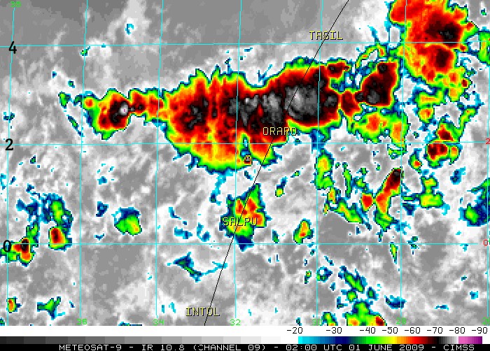
The weather map from 02:00GMT almost exactly shows the argument I was making: Directly over SALPU there's a storm cell that appears harmless. That should have appeared on the aircrafts weather radar, possibly also leading the pilots to think that it's not worthwhile circumventing that one and risk a stop-over in doing so. But would the on-board radar, looking along the projected flight path, be able to see the front behind that cell?
Now the image is from 02:00 and I do not know how these cells developed in the next minutes, but given the estimated flight time between SALPU and ORARO of 12 minutes in AF447's last radio contact, I would guess that the much fiercer looking storm system appeared on the weather radar about 3 minutes before actually entering it (when not slowing down).
I also do not know what angular field of view the weather radar has, but that second system would have subtended about 135 degrees when seen from the point where AF447 left the first system, so it would look (and be) practically impossible to go around.
Indeed this might exactly be the situation, where the RIF procedure lead to not going around the first system that appeared and was harmless, and then discovering later-on that this was (in this case) grave mistake ...
m.
P.S. Could anybody supply information about the angular field of view and possibly the range of the on-board weather radar?Comment
Comment