If this is your first visit, be sure to
check out the FAQ by clicking the
link above. You may have to register
before you can post: click the register link above to proceed. To start viewing messages,
select the forum that you want to visit from the selection below.
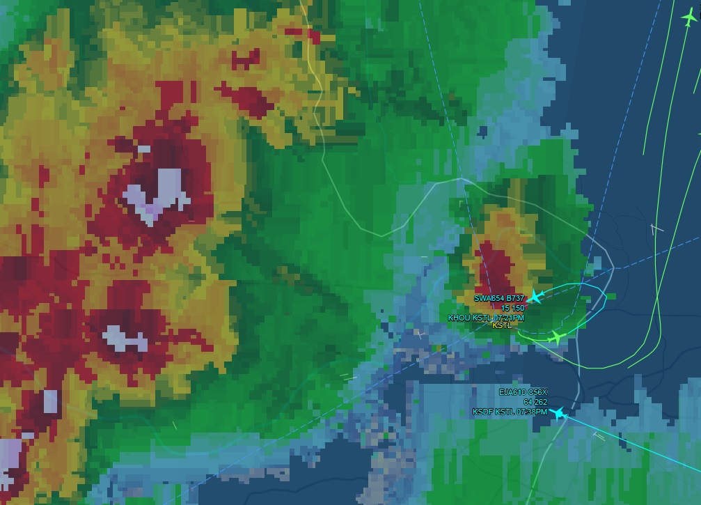
If you were onboard Southwest 654, would you be pushing the FA call button and showing your credentials and attempting to get the crew to change course?
(Sorry, you gotta click on the image to get it to a readable size).
Les r�gles de l'aviation de base d�couragent de longues p�riodes de dur tirer vers le haut.
If you were onboard Southwest 654, would you be pushing the FA call button and showing your credentials and attempting to get the crew to change course?
[ATTACH=CONFIG]6356[/ATTACH]
(Sorry, you gotta click on the image to get it to a readable size).
Gabe?
Frankly, this would scare me a hell of a lot more than a single autopilot trying to do a go-around at 1500 ft AGL (with any sort of halfway competent monitoring).
Les r�gles de l'aviation de base d�couragent de longues p�riodes de dur tirer vers le haut.
If you were onboard Southwest 654, would you be pushing the FA call button and showing your credentials and attempting to get the crew to change course?
[ATTACH=CONFIG]6356[/ATTACH]
(Sorry, you gotta click on the image to get it to a readable size).
Unfortunately, In today's age that would only get me in trouble. But from the looks of that radar shot, what the hell were they thinking?!
If you were onboard Southwest 654, would you be pushing the FA call button and showing your credentials and attempting to get the crew to change course?
[ATTACH=CONFIG]6356[/ATTACH]
(Sorry, you gotta click on the image to get it to a readable size).
What is the color scale showing? There are different parameters measured on clouds like temp of the tops, altitude of the tops, or strength of radar returns (normally associated with water content, which in turn is normally associated with convective activity, although you can have convective activity without rain and a lot of rain with no significant convective activity, like in some tropical rainfalls).
--- Judge what is said by the merits of what is said, not by the credentials of who said it. ---
--- Defend what you say with arguments, not by imposing your credentials ---
Bobby is just looking at the picture that you posted. This may or may not be totally different than what the crew saw on their radar screen. My rule is never go into the red if you have a way out. Yellow is a good thing to avoid if possible as well. When you are in the shit, and you have NO choice but to be in the shit, then I turn the gain way down so now what I am seeing is the really bad shit. I just did a flight 3 nights ago from Bagram, Afghanistan to Hong Kong. We probably added 150 -200 miles to it from en-route deviations. The box's don't complain (although I had an empty airplane) but why beat up the crew and the airplane if you can avoid it.
What is the color scale showing? There are different parameters measured on clouds like temp of the tops, altitude of the tops, or strength of radar returns (normally associated with water content, which in turn is normally associated with convective activity, although you can have convective activity without rain and a lot of rain with no significant convective activity, like in some tropical rainfalls).
Modern aviation weather radar: green, light precipitation yellow, medium precipitation and red heavy precipitation and on the fancy ones magenta is turbulence.
What is the color scale showing? There are different parameters measured on clouds like temp of the tops, altitude of the tops, or strength of radar returns (normally associated with water content, which in turn is normally associated with convective activity, although you can have convective activity without rain and a lot of rain with no significant convective activity, like in some tropical rainfalls).
As a follow up- this was a pretty interesting storm system- the atmosphere was very dynamic...lots of outflow boundaries causing little pop up cells, stuff that was quite severe, lots of hail about, a couple random tornadoes through the day.
As to your question- I ass-ume that Flightaware is a simplistic overlay of basic precipitation reflectance/intensity, although there may have been hail indirectly associated with the white stuff.
I don't think this landing was of any special significance, although it is often very interesting to watch aircraft and ATC behavior when storm systems go through.
Over a 30-min period, a Weber Cessna 206 threaded it's way south 'through' a bunch of this stuff and landed, while a number of East-bound 'big' aircraft diverted. Ironingly, a lot of aircraft from the East and Southeast would ignore a nice big gap to the South (not in this picture) and go ~100 miles Southwest and then work Northeast.
What was hilarious was to watch a Southeast bound flight make a big counterclockwise circle to the Northwest and then later, in the clear, cross paths with a Southbound flight that basically went straight south.
Also funny- I was messing with flightaware this evening as a family member was flying in from the East...This was about an hour later and the weather had shifted SE some. However, they did the deal of flying '100' miles too far Southwest, worked back Northwest, then flew 'the standard downwind' to turn around and land to the west...however, somewhere during the final stages, the wind shifted so they overflew the airport to make yet another 180 to land to the Southeast...
AS to the flight depicted in my original post- it's interesting to compare this to Delta 191...This was a random, stand-alone, smaller, towering thunderstorm (the lightning was pretty spectacular)...and while I don't doubt that the SWA plane was using on-board radar (and on-board wind shear detection), I think we can safely say that it probably flew quite close to a potentially stinky thunderstorm on final approach.
I STILL think I'd prefer to be riding on a single-autopilot go-around than getting a little intimate with thunderstorms.
Les r�gles de l'aviation de base d�couragent de longues p�riodes de dur tirer vers le haut.
Another interesting YouTube showing what looks like nasty clouds and an aircraft operating in close proximity. (Yes, of local interest to some forumites).
In defense of the reckless, improvisational cowboys, it seems that the storm both missed the airport AND passed the airport..
On the other hand, it does look like quite the textbook inflow into a fairly feistily CB...a few short miles away from the airport. I also see a kind of significant crosswind input - so maybe it was kinda gusty/windy from the storm. I note the comment from an amateur meteorologist that it looks ripe for a funnel cloud...(It does, BUT, more often than not those structures do NOT produce funnel clouds- it's kind of a cart-before-the-horse deal).
Reminder/Disclaimer: I still appreciate Bobby's respect for thunderstorms, but conversely think that the industry isn't always keeping "20 miles away from stuff" maybe as much as they should- and am genuinely interested in his commentary.
Les r�gles de l'aviation de base d�couragent de longues p�riodes de dur tirer vers le haut.
We process personal data about users of our site, through the use of cookies and other technologies, to deliver our services, personalize advertising, and to analyze site activity. We may share certain information about our users with our advertising and analytics partners. For additional details, refer to our Privacy Policy.
By clicking "I AGREE" below, you agree to our Privacy Policy and our personal data processing and cookie practices as described therein. You also acknowledge that this forum may be hosted outside your country and you consent to the collection, storage, and processing of your data in the country where this forum is hosted.
 Tweet
Tweet
Comment